
Chicago River Tour
这篇 blog 的中文版本。
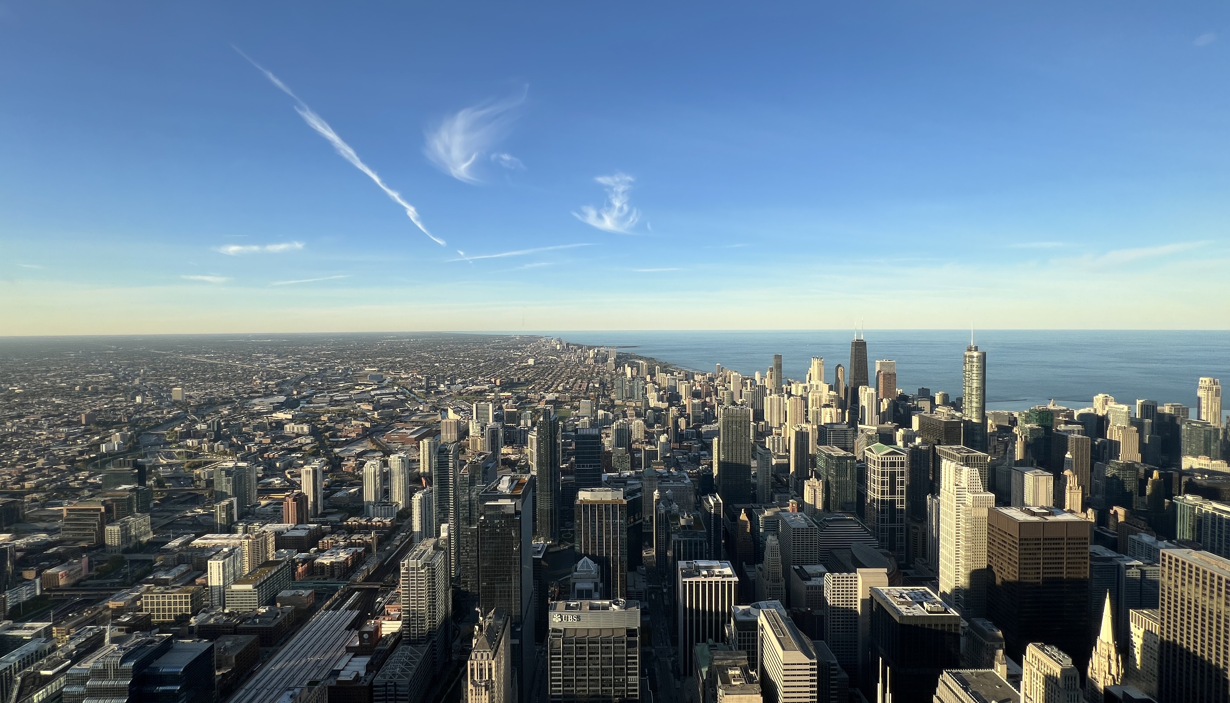
The Beauty of Chicago: series 1.
Chicago, located in the northeastern corner of Illinois along the shores of Lake Michigan, is a major hub city in the Midwest region of the United States. In terms of both population and economic scale, Chicago ranks among the top three cities in the country, alongside New York City and Los Angeles. Although Chicago was not one of the earliest cities founded at the birth of the United States, it has played a crucial role in the nation’s history. Since officially adopting the name “Chicago” in 1837, the city has exerted a profound influence on American politics, culture, art, and economy.
Chicago is also known as “The Windy City.” Many people assume this nickname comes from Chicago’s often windy weather—especially in winter—but the story behind it goes deeper than that. The term “Windy City” emerged in the late 19th century, though its exact origin remains debated to this day. One theory is that it arose from the fierce rivalry between Chicago and Cincinnati, Ohio, especially in the political arena. In 1876, the two cities were competing for the right to host the Republican National Convention four years later. On March 9 of that year, a Cincinnati commentator wrote an article in the Cincinnati Enquirer using the phrase “windy city” to mock Chicago politicians as boastful and full of empty promises. Another explanation ties the nickname to Chicago’s bid to host the World's Columbian Exposition in 1893. At the time, Chicago was competing with New York City and other major U.S. cities, and its politicians enthusiastically promoted Chicago’s beauty, vitality, and prosperity. Officials from rival cities, dismissing these claims as exaggerated and fanciful, labeled Chicago the “Windy City.” Although the exact origin of the nickname may never be fully confirmed, it was almost certainly meant as an insult when it first appeared in history. Over time, however, as Chicago rapidly developed during the 19th and 20th centuries into a truly vibrant and prosperous global metropolis, the term “Windy City” gradually shed its negative connotation and became a proud and positive symbol of the city.

Chicago River
Introduction
The Chicago River refers to a network of rivers and waterways running through the Chicago metropolitan area. It consists mainly of three parts: the North Branch, the South Branch, and the Main Stem. Including its major tributaries, the river system stretches about 156 miles (approximately 251 kilometers) in total.
The Main Stem flows eastward into Lake Michigan, while the North Branch connects with the lake near the northern edge of the city in Evanston. The South Branch extends southward and eventually joins the Mississippi River, which carries its waters all the way down to the Gulf of Mexico.
Spanning the entire metropolitan region, the Chicago River has long been a vital part of the city’s development, shaping its geography, commerce, and infrastructure.
Although the Chicago River is not particularly long, it has played a crucial role in the city’s history. By linking Lake Michigan—one of the Great Lakes—with the Mississippi River, the second-longest river in the United States, it became a vital waterway between the Lake Michigan region and the south-central parts of the country. This connection greatly accelerated Chicago’s rise as a major commercial hub of the Midwest.
The Reverse of the Flow
Before the mid-19th century, the Chicago River flowed slowly from the plains west of Chicago toward Lake Michigan. Its sluggish current made it difficult for the river to naturally flush and renew itself, which led to severe water pollution. During periods of bad weather, large amounts of sewage would flow directly into the river and the lake, further worsening both water contamination and water shortages in the Chicago metropolitan area.
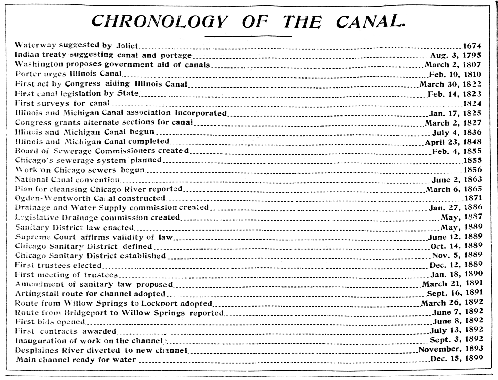
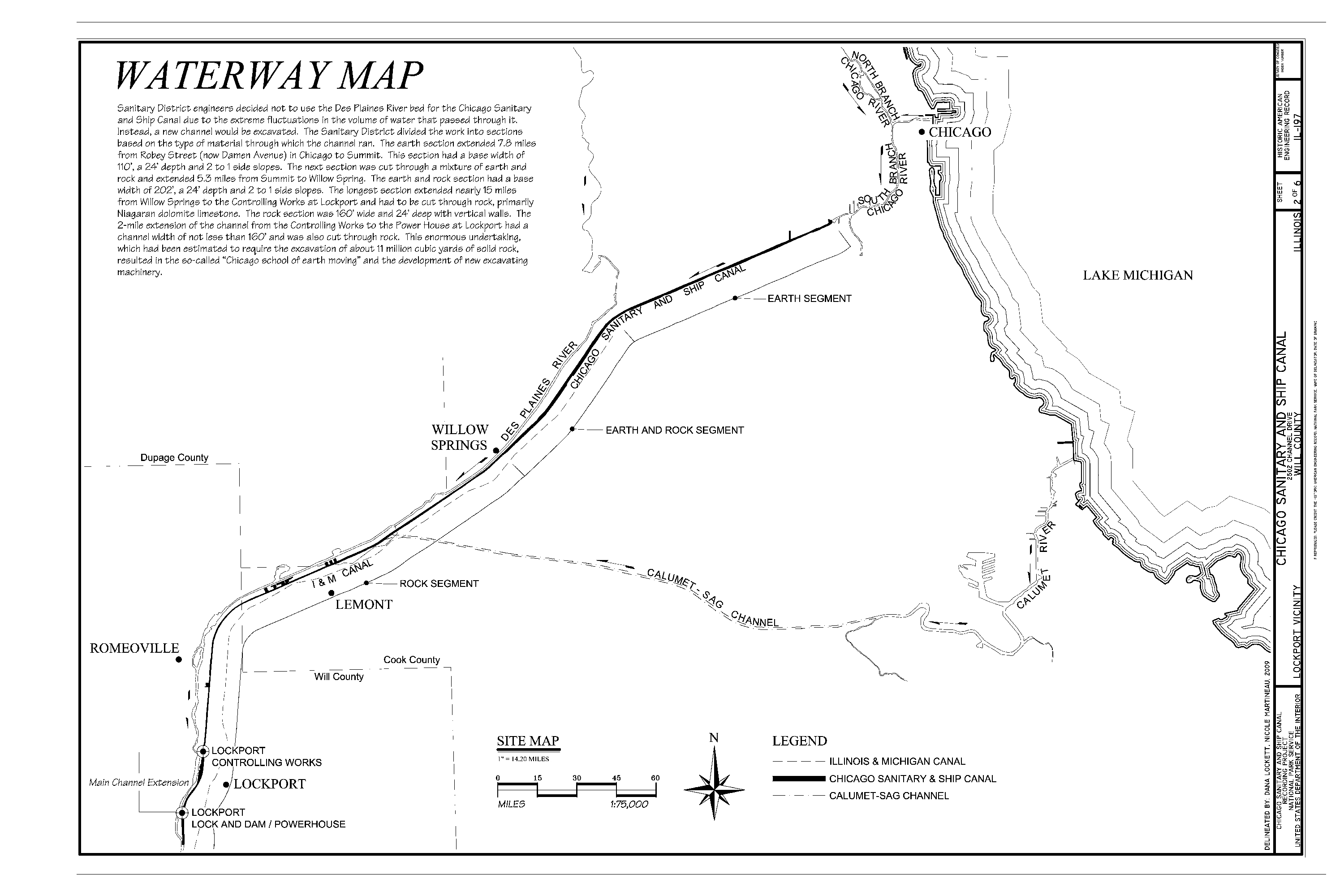
Over time, the chronic pollution triggered a series of public health crises, especially outbreaks of infectious diseases such as cholera and typhoid fever. In 1887, the Illinois General Assembly officially decided to reverse the river’s flow through a massive engineering project. The plan called for the construction of the Chicago Sanitary and Ship Canal—a 28-mile (about 45 km) canal in the southwestern part of the city—linking the river’s South Branch to the Des Plaines River.
When completed in 1900, this ambitious project permanently reversed the flow of the river’s main branches. It solved the city’s water pollution crisis, created a navigable water route between Lake Michigan and the Mississippi River, and laid the groundwork for Chicago’s subsequent economic growth. To this day, the canal remains the only waterway connecting Lake Michigan to the Mississippi River.
In 1999, the American Society of Civil Engineers named the river reversal project and its water management system a Civil Engineering Monument of the Millennium, recognizing it as one of the most significant engineering achievements in modern history.
The Architectural Tour on the Chicago River
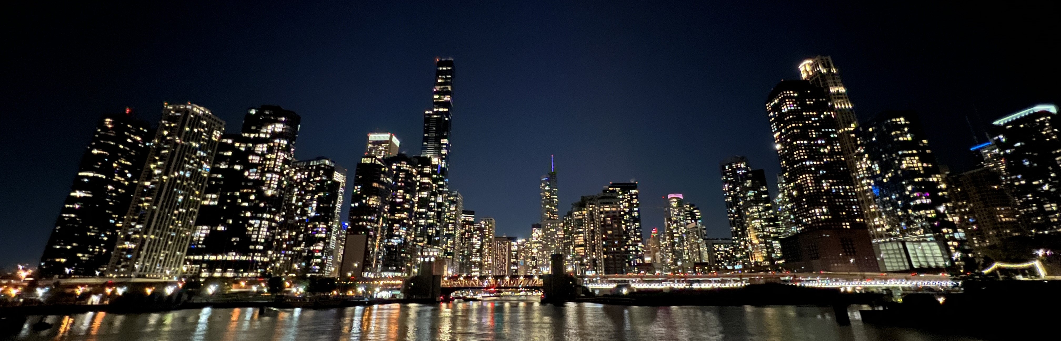
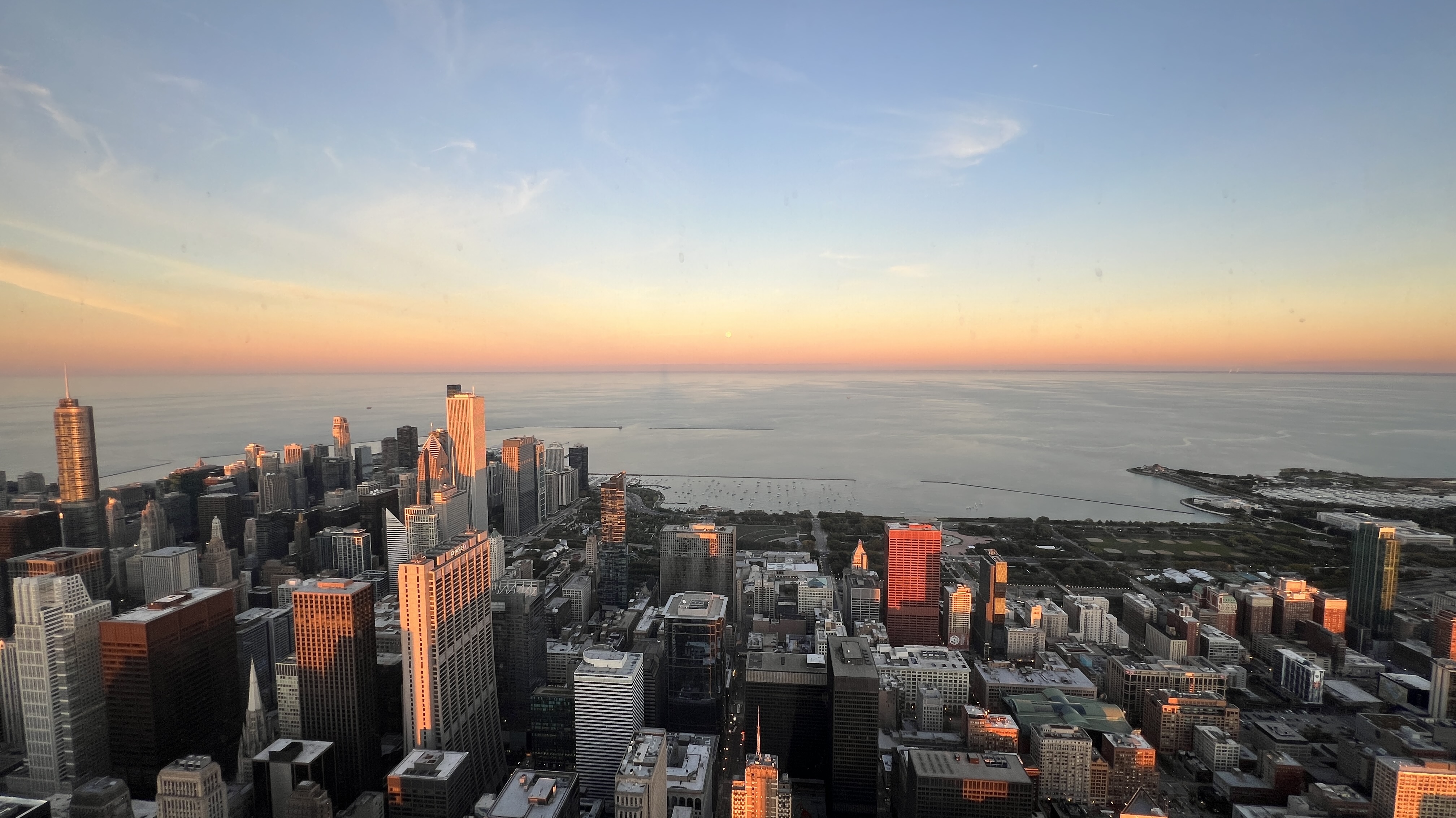
If someone comes to visit but only has half a day before leaving, I would immediately take them to the docks along the river for a cruise. Whether it’s the architects’ shared vision or simply the river’s prime location, nearly all of Chicago’s iconic buildings and landmarks line its banks, making a boat tour one of the best ways to see the city.
In just a short 90-minute cruise weaving through towering skyscrapers, passengers can appreciate the diversity and intricacy of Chicago’s architecture, as well as the city’s bustling energy and vibrant prosperity.
The following buildings are introduced in roughly the order they appear along the route of a boat tour departing from the east side of the DuSable Bridge.
The Wrigley Building 
The Wrigley Building is located at 400–410 North Michigan Avenue in Chicago, on the northwest corner of the Michigan Avenue Bridge and at the intersection of the Chicago River and the city’s renowned “The Magnificent Mile.” Around 1910, William Wrigley Jr., the founder of the Wrigley Company, decided to build this skyscraper in Chicago as the company’s headquarters. Construction began in 1920 and consisted of two sections: the South Tower and the North Tower. The South Tower was completed in 1921, and the North Tower was completed in 1924. The building’s design was inspired by the bell tower of the Seville Cathedral in Spain and the architectural style of the Renaissance in France. All six façades of each tower are clad in a distinctive bright white terra cotta. In the World’s Columbian Exposition held in Chicago in 1893, the city earned the nickname “White City,” which is said to have inspired William Wrigley Jr. when envisioning the building’s exterior.
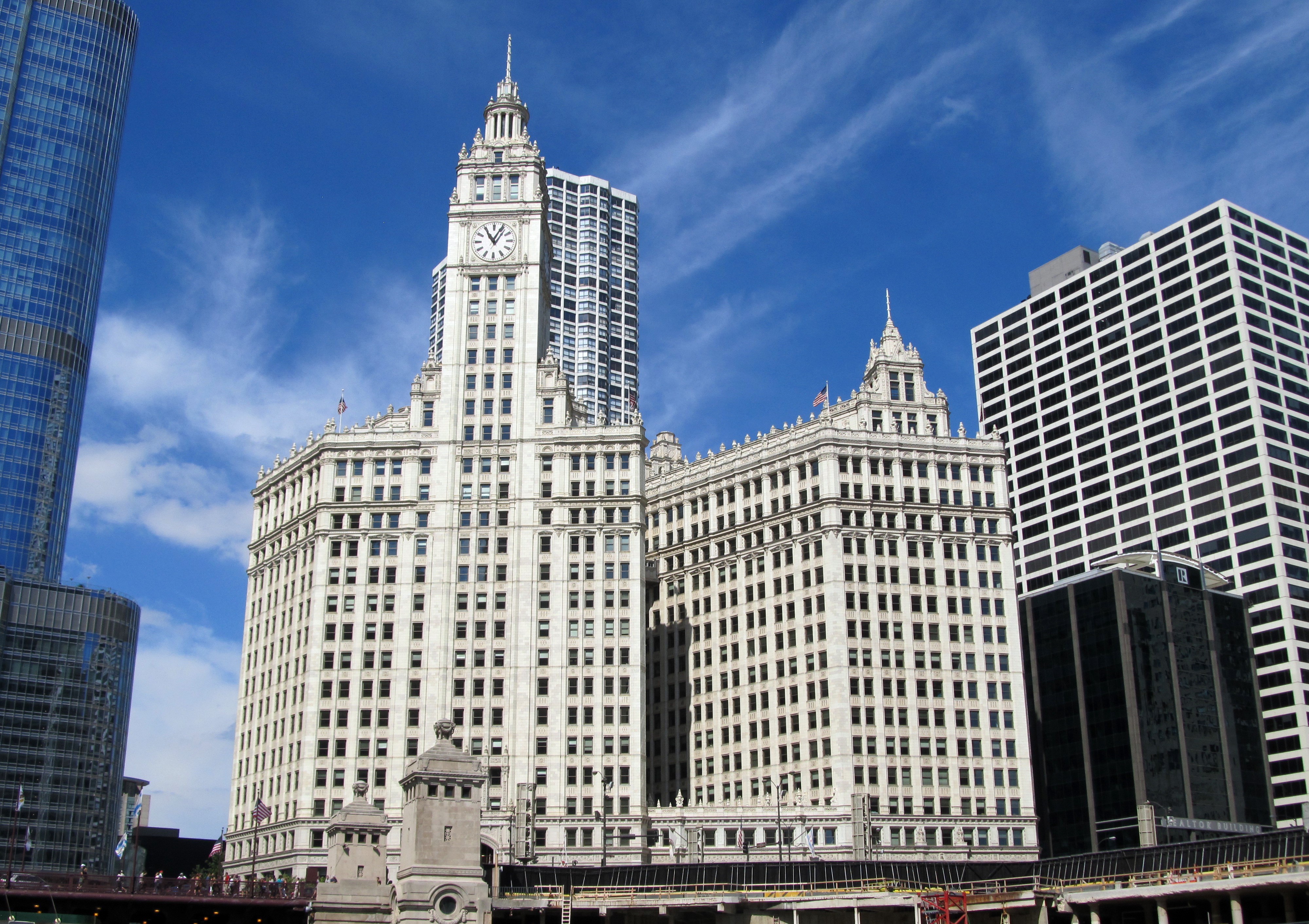
The Wrigley Building is no longer the headquarters of the Wrigley Company. The company sold the building in 2010, and it has since become a mixed-use office building housing offices, hotels, restaurants, and retail spaces.
Located in the heart of Chicago’s bustling commercial district, the Wrigley Building is a staple in the photo albums of nearly everyone who has visited Chicago and strolled through downtown. In 2012, it was designated as one of Chicago’s landmarks.
Did you know?
• The Wrigley Building was the first air-conditioned building in Chicago.
• When the Wrigley Building was completed, Michigan Avenue was not as bustling as it is today. The steel bridges connecting the two sides of the Chicago River next to the Wrigley Building had not yet been built. This led people to believe that the birth of the Magnificent Mile started with the Wrigley Building.
• The Wrigley Building was designed by the architectural firm Graham, Anderson, Probst & White. This firm was also responsible for designing the famous Field Museum of Natural History in Chicago in the early 20th century.
Marina City
Marina City is located at 300 N State St, 60654, on the north bank of the Chicago River. It has a unique corn cob-like appearance, making it easily recognizable at a glance. However, Marina City’s uniqueness goes far beyond its appearance. Marina City consists of two “cities” that are almost identical in appearance and internal structure. They were designed by architect Bertrand Goldberg in 1959 and finally completed in 1969. When designing this building, Bertrand Goldberg based it on a very avant-garde idea at the time: a city within a city. That is, the building is not simply used as a residence or office building, but is able to fully support all the most basic facilities of a city and have the basic functions of a city. This idea was later realized in the construction of Marina City. The bottom 19 floors of any “city” in Marina City are spiral parking lots, providing parking spaces for residents within the “city”. Floors 20-60 are residential areas, including residents’ rooms, supermarkets and pharmacies, restaurants, bars, swimming pools, gyms, and more. The 61st floor is an open panoramic observation deck. The underground of the “city” is a large dock for mooring yachts of residents or visitors.

The concept of a “city within a city” envisioned by Bertrand Goldberg was rooted in the phenomenon of “White flight”, which became prevalent in certain American cities during the 1950s and 1960s. At that time, the United States was experiencing a surge of both domestic and international migration, with large numbers of African Americans, Mexican Americans, and immigrants from overseas moving into northern cities. Due to racial tensions, social hierarchies, and disparities in resource allocation, many white Americans of European descent chose to leave the cities and relocate to surrounding suburbs or even rural areas.
The phenomenon of White flight was a key factor in the Suburbanization and Urban decentralization of the mid-20th century in the U.S., and it further accelerated these processes. From the 1950s to the 1970s, many Midwestern and central U.S. cities were heavily affected by this trend, including Chicago, Baltimore, Cleveland, Detroit, Kansas City, and Oakland. It was in this context that Bertrand Goldberg proposed the idea of a “city within a city,” hoping to use this distinctive architectural form to mitigate White flight and its impact on urban centers.
Due to its unique appearance and interior structure, Marina City went on to inspire many subsequent buildings, including The Corinthian in Manhattan, and has frequently appeared in literature and film works set in Chicago. In 2016, Marina City was officially designated as a Chicago Landmark.
Did you know?
• Inside Marina City, you can hardly find any right angles. Each floor of Marina City is very "rounded": the parking garage is a 19-story spiral; each residential floor has units arranged in a circle around the central elevator core, and even the balconies are part of the circular design!
• All modern facilities in Marina City have been powered entirely by electricity since its completion. This means that no propane or natural gas is used inside the building (which also means there are no open-flame stoves!). Therefore, there are no central air conditioning, hot water, or heating systems in Marina City; all these facilities are installed and used by the residents and businesses themselves, and the electricity consumption is also borne by them. It is said that this is due to an agreement between the developer of Marina City and the local electric company, Commonwealth Edison: if Marina City is entirely powered by electricity, Commonwealth Edison would build a substation for Marina City free of charge, which was quite expensive at the time.
• When Marina City was completed, it was the tallest reinforced concrete building in the world, a title it held until 1976 when it was surpassed by the Water Tower Place, which in turn was surpassed by the Trump International Hotel and Tower in 2009. Both Water Tower Place and Trump International Hotel and Tower are located in Chicago.
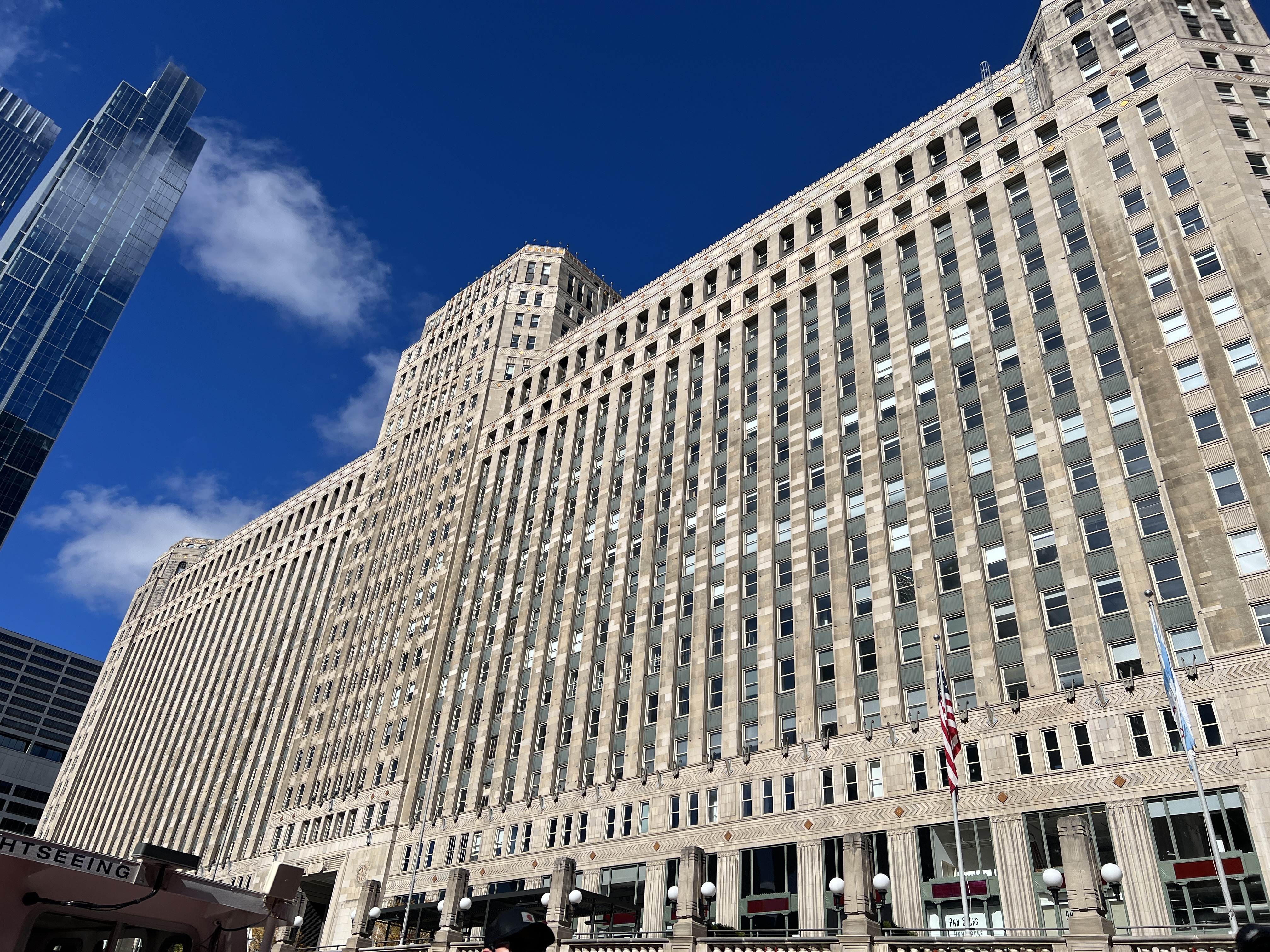
Merchandise Mart, or The Mart
Located at 222 W Merchandise Mart Plaza, 60654—right at the Y-shaped junction of the Chicago River—the Merchandise Mart is an enormous commercial complex in Chicago. The building houses a wide variety of facilities related to business activities, including retail shops, warehouses, and shopping plazas.
When the Merchandise Mart was completed in 1930, its footprint was an astonishing 4 million square feet (about 372,000 square meters)—roughly equivalent to 52 standard football fields. This made it the largest building in the world by floor area at the time, a title it held until 1943 when it was surpassed by the Pentagon. The building was so massive that for a long period it even had its own ZIP code (60654).
Constructing such a colossal structure was by no means an easy feat. Massive barges carrying cement materials docked at the Chicago River junction, where the materials were transported 20 meters upward using compressed air. Giant cement mixers inside the building mixed the materials, and the concrete was then loaded onto hoists mounted on vertical tower cranes—which were themselves extended upward as construction progressed. Sand and gravel were brought in by train to sites near the construction area, then carried up to the elevated work platforms via long conveyor belts and freight elevators.
From the groundbreaking of the Merchandise Mart in 1928 to its completion in 1930, the project consumed 29 million bricks, 40 miles (64 km) of piping, 380 miles (610 km) of wiring, 3.1 million cubic meters of concrete, 5,700 cubic meters of stone, and 60,000 tons of steel. Upon completion, the building featured 4,000 windows and as many as 30 elevators. In total, about 5,700 workers were directly involved in its construction, which cost more than 26 million U.S. dollars at the time.
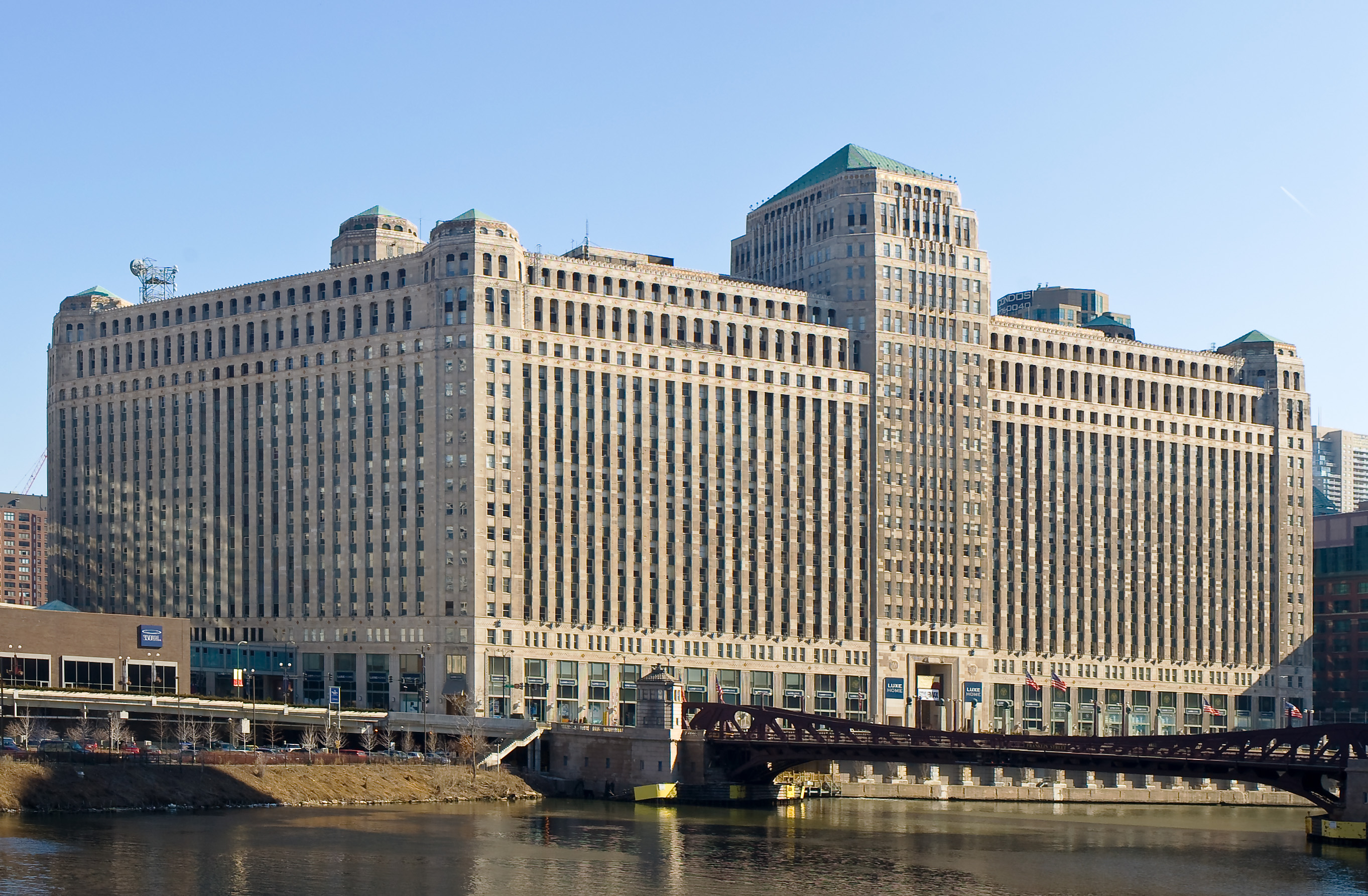
The Merchandise Mart was designed in the Art Deco style, with both its exterior and interior showcasing exquisite detailing. Art Deco was a highly popular architectural style in the first half of the 20th century, characterized by geometric patterns, ornamental detailing, and symmetrical forms.
Some of the most iconic buildings that adopted the Art Deco style include the Chrysler Building, the Empire State Building, and the Rockefeller Center in New York; the Palais de la Porte Dorée in France; and the Shanghai Tower and Peace Hotel in Shanghai, China.
Did you know?
• The Merchandise Mart was owned by the Kennedy family for a long time until it was sold to the real estate company Vornado Realty Trust in 1998.
• The site of the Merchandise Mart was originally a small trading post and the Wells Street Station of the Chicago and North Western Railway. The station was closed after the Chicago and North Western Passenger Terminal (now Richard B. Ogilvie Transportation Center) was built in 1911. However, the remaining railway tracks provided convenient conditions for the construction of the Merchandise Mart.
Movable Bridges
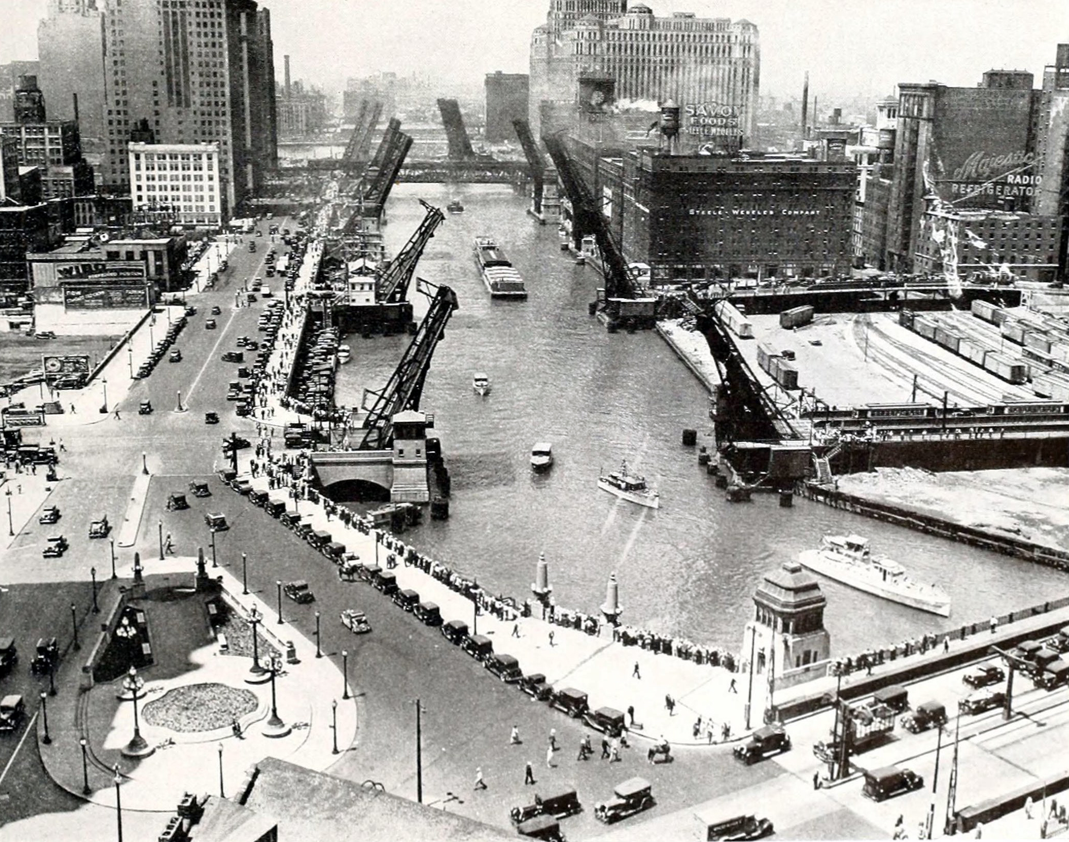
When introducing the architecture of a city, bridges generally do not take center stage. However, this is not the case in Chicago. Due to the presence of the Chicago River, the bridges spanning its banks have left a significant mark on the city’s history and have gradually become one of its symbols.
Unlike the typical bridges we see, most of the bridges over the Chicago River are movable. This does not mean that the bridge can freely move along the river to where it is needed, but rather that it can be “lifted” or “lowered” when necessary to allow boats to pass underneath.
History
Although today there are numerous bridges spanning the Chicago River, making it easy to cross from one side to the other, things were quite different back in the 1820s. At that time, crossing the river was a cumbersome task. Common means of transportation included ferries and rafts.
The idea of building a convenient and permanent bridge had been proposed early on, but it also faced strong opposition. First, the development on the river’s south bank was much more advanced than on the north bank, and merchants on the south side feared that a bridge would allow their business to be taken away by the north side. Second, many people’s livelihoods depended on river crossings — such as ferry owners, ferrymen, raft builders, and those providing food and lodging to them — and they worried that building a bridge would put them out of work. Third, the river was a busy hub for shipping at the time, and many feared that a bridge would block large vessels from entering the port of Chicago.
For all these reasons, the bridge project was delayed for a long time. In 1832, residents on the north bank fully funded the construction of the first permanent bridge for pedestrians and horse-drawn carriages near what is now Kinzie Street. It was the first permanent bridge in the history of the Chicago River.
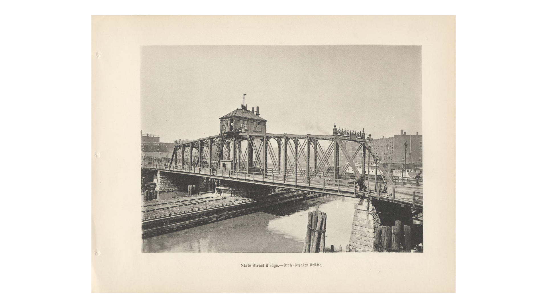
Soon after, more pedestrian bridges connecting the north and south banks were built. The first movable bridge was constructed in 1834 near what is now Dearborn Street. However, it suffered from serious design flaws, frequently malfunctioning and failing to “lift” or “lower” properly, which disrupted both pedestrian and vehicular traffic. In severe cases, breakdowns forced people and vehicles on both sides to wait for hours or even days.
The first railroad bridge across the Chicago River was built in 1852, also near Kinzie Street. Today, Chicago has the second-largest number of movable bridges in the world — surpassed only by Amsterdam in the Netherlands.
How does it work?
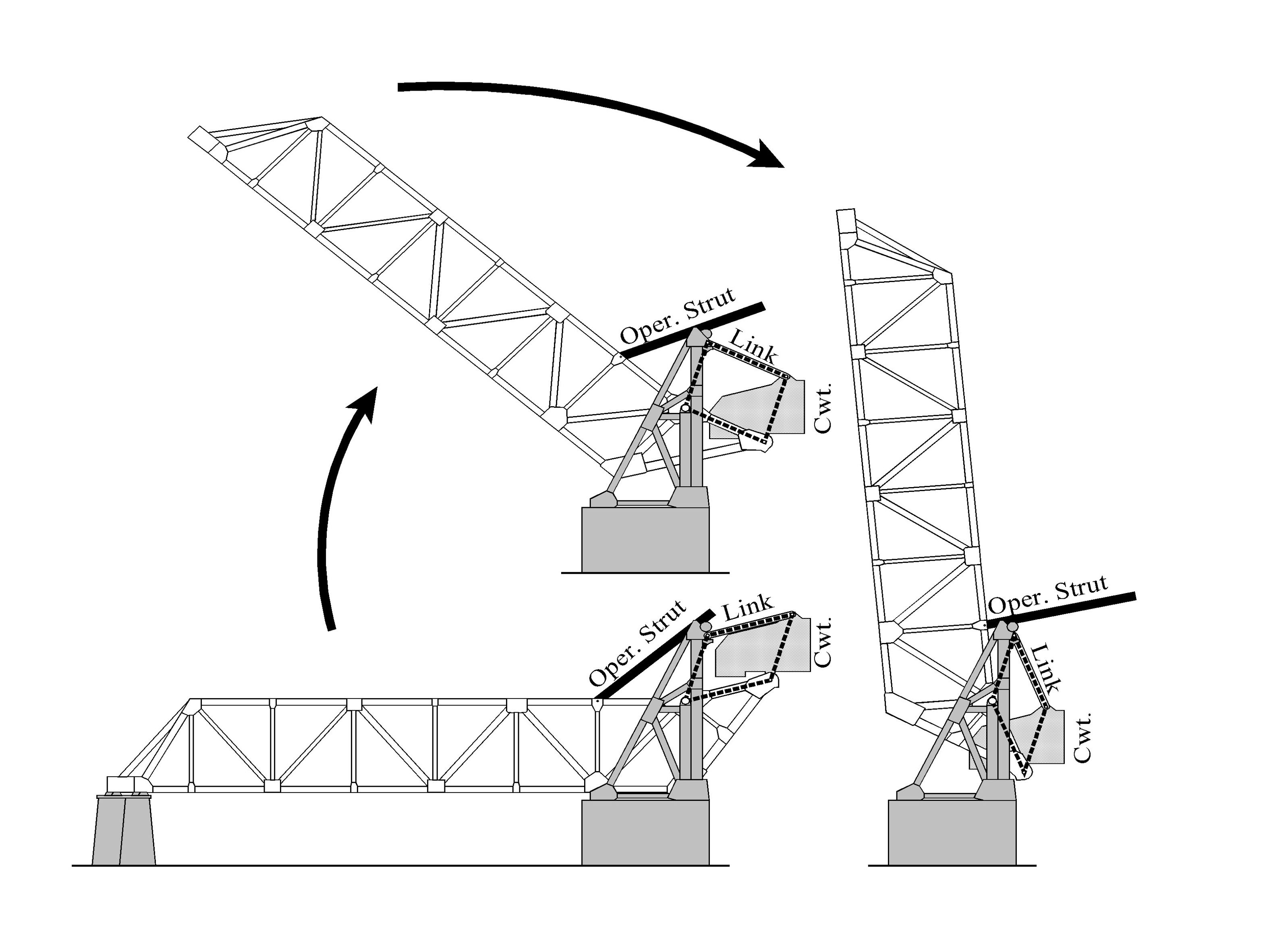
Movable bridges are generally powered by electricity. In the 19th century, electricity was a very expensive resource. To save costs, most early bridges were designed so ingeniously that they required very little power to “lift” or “lower” the bridge. Common types of movable bridges can be roughly divided into the following categories:
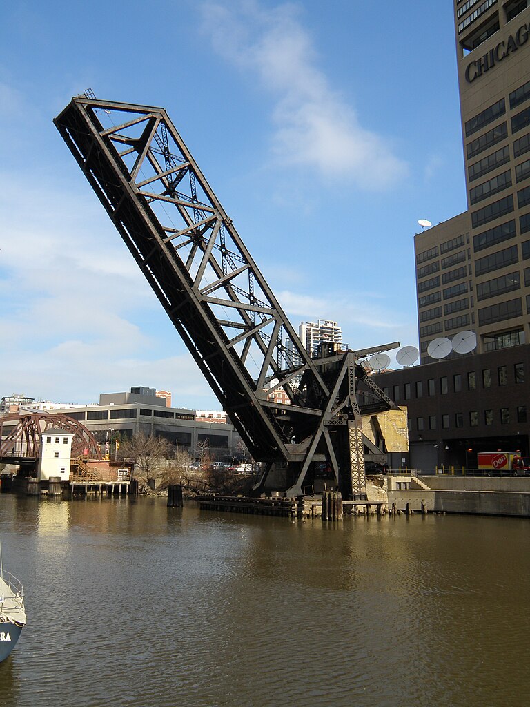
Trunnion Bascule Bridge
The trunnion bascule bridge is the most common type of movable bridge on the Chicago River today. It can be further divided into double-leaf bascule bridges and single-leaf bascule bridges, depending on whether the bridge “breaks” in the middle during operation. Regardless of the type, the basic working principle of a bascule bridge is the lever principle. Each leaf consists of the bridge deck, a central axis (trunnion), and counterweights. The weight of the counterweights is precisely controlled so that the torque they exert on the trunnion is slightly less than the torque exerted by the bridge deck. This allows the bridge deck to be “lifted” and “lowered” with minimal force. Each leaf also contains intricate mechanical structures to ensure smooth rotation of both the bridge deck and counterweights around the trunnion.
Center Pier Swing Bridge
As the name suggests, this type of bridge operates by rotating the entire bridge deck around a central pier. When the bridge deck rotates to be parallel with the river channel, boats can pass through. Due to the significant space requirements for this type of bridge (it needs a central pier that can support the weight and rotation, as well as enough remaining river channel width after rotation for boats to pass), it is not common in the downtown area of the Chicago River.
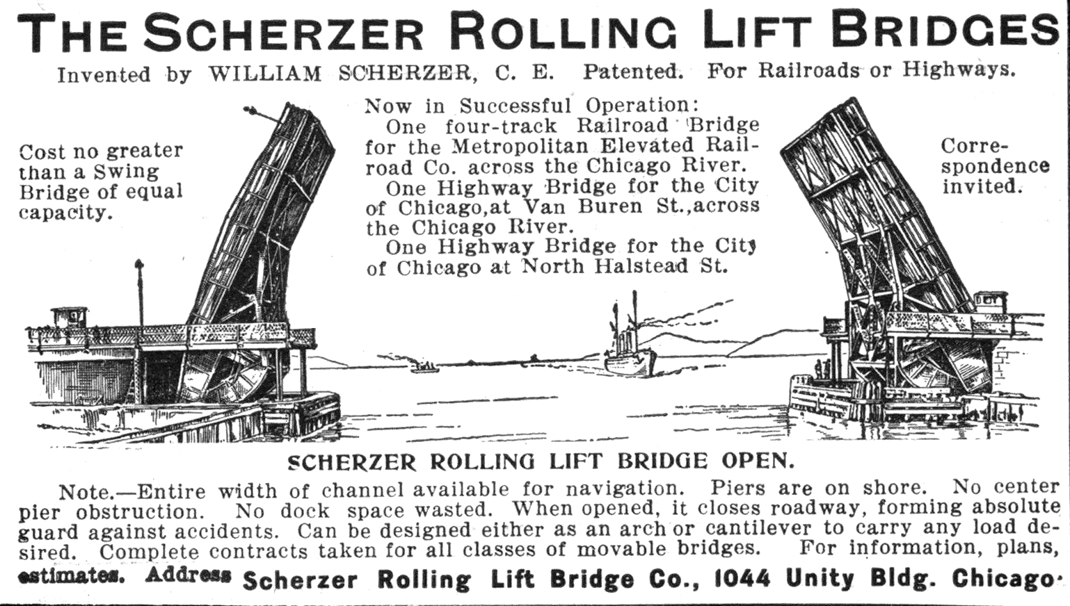
Scherzer Rolling Lift Bridge
Named after its inventor William D. Scherzer, the Scherzer rolling lift bridge operates similarly to a bascule bridge, but replaces the lever mechanism with large rolling discs. The advantage of the Scherzer rolling lift bridge is its high reliability and low likelihood of failure, while the disadvantage is the need for a larger space to accommodate the rolling discs.
Bridge Tender
“The tramp, the wharf rat, and the river pirate are [the bridge tender’s] neighbors.” -Chicago Tribune, 1896
To this day, near many important movable bridges in Chicago, you can find a small white house called a Bridge Tender House. It serves as the workplace (and sometimes residence) for the bridge tender. The primary responsibility of the bridge tender is, of course, to control the “lifting” and “lowering” of the bridge at the appropriate times according to schedule, allowing boats, pedestrians, and vehicles to pass safely. However, the full scope of the bridge tender’s work goes far beyond this. They must also regularly inspect and maintain the bridges to ensure they are in good working condition, handle any emergencies related to the bridges, find and remove vagrants on the bridges, rescue people who fall into the river carelessly, and even prevent the people who step in the bridge because of the loss of hope of their lives.
There are currently 70 Bridge Tender Houses in Chicago, distributed along the three main branches of the Chicago River. Bridge tenders used to stay in these houses day and night, monitoring the condition of the bridges. However, with the passage of time, major commercial ships heading to Chicago no longer enter the inner Chicago River but dock at the Port of Chicago, significantly reducing the working hours of bridge tenders. Today, only 7 Bridge Tender Houses are staffed 24 hours a day, while most are unstaffed more than 95% of the year, with bridge tenders only arriving at these houses on specific dates when the bridges need to be “lifted.”

For more stories about bridge tenders and Bridge Tender Houses, please visit https://www.tenderhouseproject.com/chicagobridgehouses.
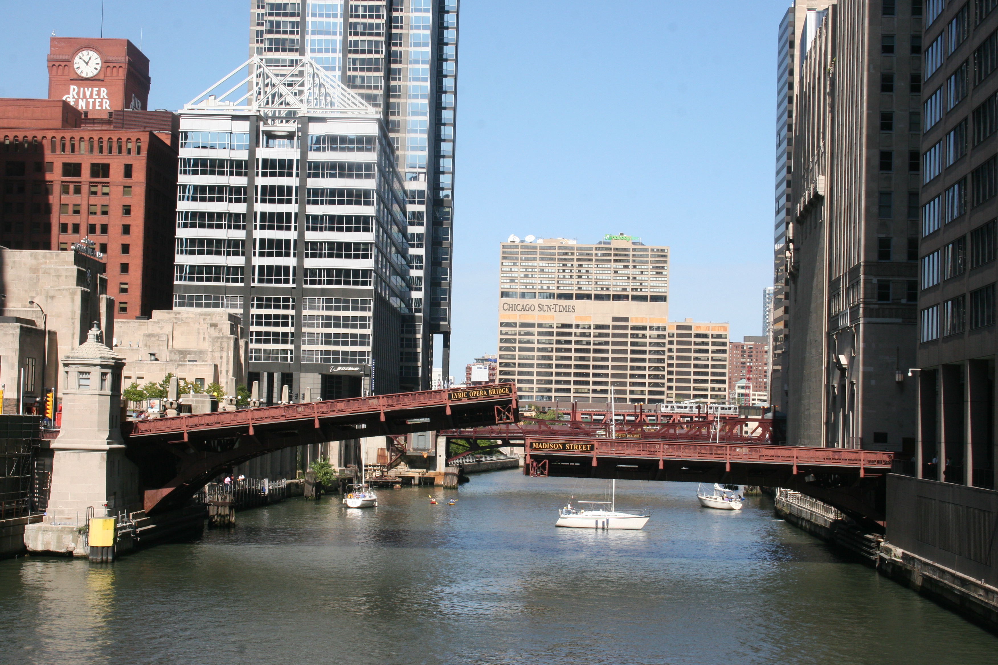
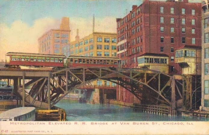
Kinzie Street Railroad Bridge
If you take a boat tour along the Chicago River, you’ll likely notice a bridge on the North Branch that is almost always in the “raised” position — the Kinzie Street Railroad Bridge. Built in 1908, it is a single-leaf bascule bridge. When it was completed, it was the largest and heaviest bascule bridge in the world. It once served as a spur of the Union Pacific Railroad, providing rail service to the many companies and factories along the east bank of the North Branch.
As transportation infrastructure in the city became more developed, the efficiency of this rail line gradually declined. In 2000, when The Chicago Sun-Times newspaper relocated its printing plant (this newspaper appeared in an earlier photo in this blog — can you spot it?), the bridge lost its last remaining client on the east bank, and the rail line was soon shut down. Since then, the Kinzie Street Railroad Bridge has been left semi-permanently locked in the “raised” position.
Today, you can still see remnants of the old railroad tracks on both sides of the bridge. Although it stays “raised” most of the time, it is lowered once a year for routine inspection. Will you be lucky enough to witness that rare moment?
Afterword
There are many stories and people related to the bridges over the Chicago River throughout history. If you are interested in them, you might want to visit the McCormick Bridgehouse & Chicago River Museum located in downtown Chicago.
Did you know?
• Most of the movable bridges over the Chicago River are regularly "lifted." If you want to witness this process in person, you can visit https://chicagoloopbridges.com/schedule.html to check the dates and times.
• William D. Scherzer, the inventor of the Scherzer rolling lift bridge, was also responsible for designing the observatory building (Dearborn Observatory) at Northwestern University.
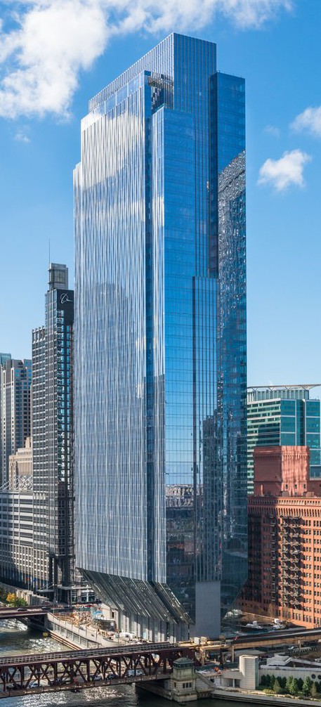
150 N Riverside Plaza
150 N Riverside Plaza, built in 2017, is located on the west bank of the South Branch of the Chicago River. Like the Chicago Merchandise Mart, it is also situated at the “Y” shaped confluence of the Chicago River. Standing at 229 meters tall, 150 N Riverside Plaza is a modern skyscraper in Chicago.
What makes 150 N Riverside Plaza unique is its design. The entire building is very slender, and to save on foundation space, the building is narrower at the base and wider at the top. The foundation’s footprint is only about 25% of the footprint of the wider upper portion.
is narrower at the base and
wider at the top.
Tall buildings are usually sensitive to strong winds, as the wind pressure can cause them to sway, which may affect the activities of people inside and, in severe cases, even threaten the structural safety of the entire building. This effect becomes more noticeable as a building becomes taller and more slender.
For the building at 150 N Riverside Plaza, its unique design required the designers to take this issue into serious consideration during the early design phase. To keep the building stable under strong winds, several tuned mass dampers (TMDs) filled with liquid were installed on its upper floors. Each TMD consists of a massive water tank designed so that its natural frequency is very close to that of the building itself. Before strong winds arrive, these tanks are filled with water. When strong winds hit, the large mass of water in the tanks moves at nearly the same frequency as the building but in the opposite direction, producing a counteracting torque that partially offsets the building’s swaying.
Tuned mass dampers are commonly used in tall buildings to reduce the effects of wind. In addition to liquid-based TMDs, solid TMDs are also widely used, and they work on a similar principle. For more information about tuned mass dampers in tall buildings, you can refer to: https://en.wikipedia.org/wiki/Tuned_mass_damper.
Did you know?
• The headquarters of the famous Hyatt Hotels Corporation is located in 150 N Riverside Plaza.
• Although 150 N Riverside Plaza is not among the tallest buildings in Chicago, and not even in the top ten tallest skyscrapers in the city, it is the tallest building on its riverbank. This shows that sometimes choice is more important than effort!
Lyric Opera of Chicago
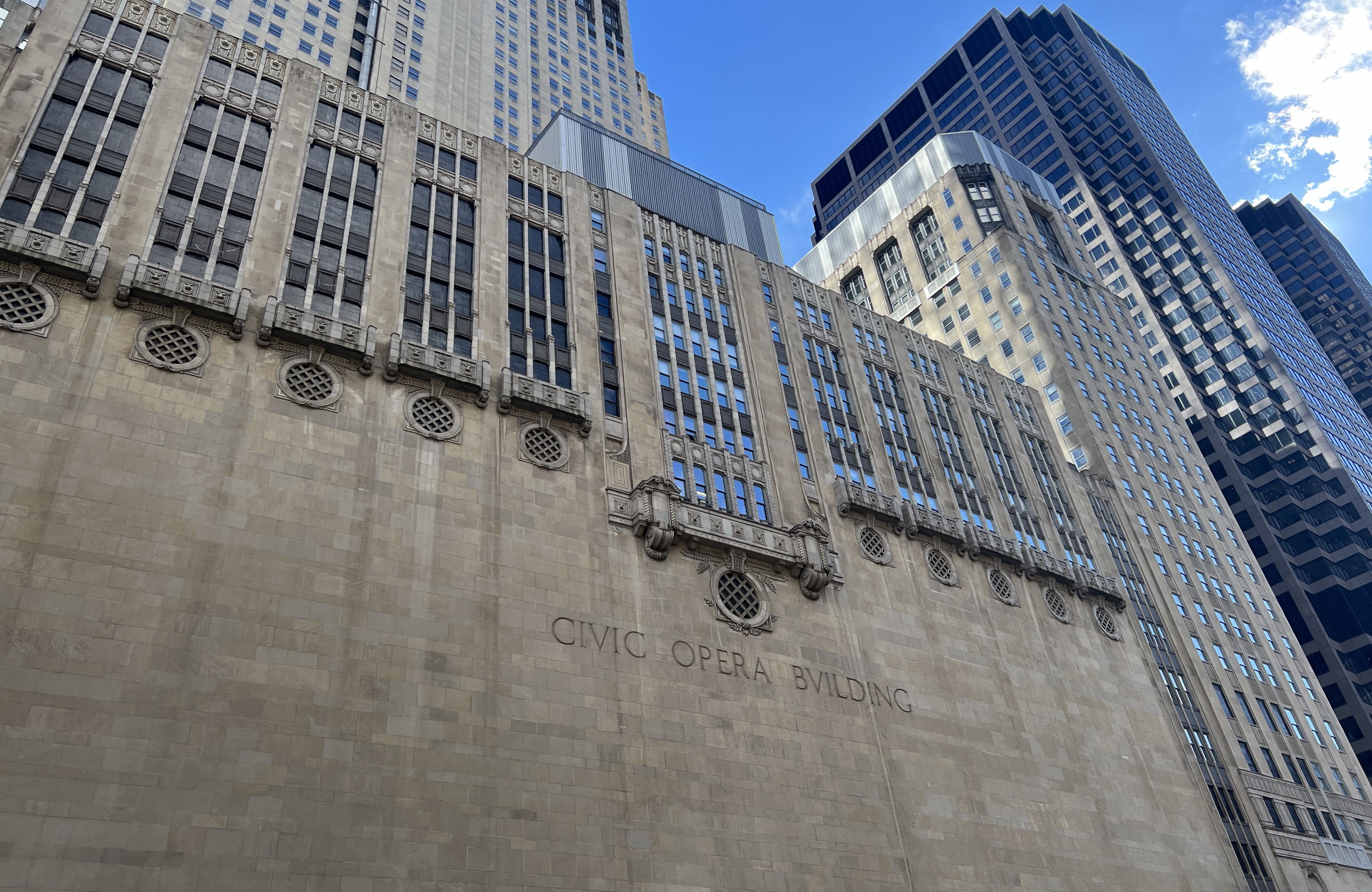
The Chicago Opera House is located at 20 N Wacker Drive, Chicago, IL 60606. It was built in 1929 on the east bank of the North Branch of the Chicago River and has stood for nearly a century. When it was first constructed, it served as the home of the Chicago Civic Opera. However, the company went bankrupt during the Great Depression. After several bankruptcies and reorganizations, it was reestablished and renamed the Lyric Opera of Chicago in 1954. Since then, the Chicago Opera House has remained the headquarters of the Lyric Opera of Chicago.

The construction of the Chicago Opera House was initially proposed by Samuel Insull, the president of the Commonwealth Edison Company in the Chicago area. Samuel Insull commissioned the architectural firm Graham, Anderson, Probst & White (has this firm appeared somewhere before?) to design and build the Chicago Opera House. The building consists of a main tower and two subsidiary towers, with the main tower standing 45 stories tall and the two subsidiary towers each 22 stories tall. The interior design of the Chicago Opera House features Art Deco elements, with meticulous attention to detail in every door, window, beam, and load-bearing column. The overall style is artistic and classical, befitting its function as a theater. The main auditorium has 3,563 seats, making it the second-largest theater in North America, after the Metropolitan Opera House in New York. Throughout the 20th century, many renowned opera singers from around the world chose the Chicago Opera House as the venue for their North American debuts. For a list of these performers, see https://en.wikipedia.org/wiki/Lyric_Opera_of_Chicago.
The first opera performed in Chicago was “La sonnambula” in 1850, but the exact venue is unknown. The city’s first opera house was built in 1865 but was destroyed in the Great Chicago Fire just six years later. The second opera house in Chicago was the Auditorium Building on South Michigan Avenue, completed in 1889 and still standing today. The Chicago Opera House is the third opera house in the city.
Did you know?
• The exterior of the Chicago Opera House resembles a giant chair, facing east with its back to the west. This design choice is related to Samuel Insull. Before coming to Chicago, Samuel Insull worked with Thomas Edison in New York. Due to dissatisfaction with a company acquisition, he resigned from his position in New York shortly after the acquisition was completed. At that time, the former president of Commonwealth Edison had just retired, and the company was busy preparing for the 1893 World's Columbian Exposition in Chicago. In this context, Samuel Insull was invited to become the president of Commonwealth Edison, a position he gladly accepted. When discussing the design of the Chicago Opera House with Graham, Anderson, Probst & White, Samuel Insull requested that the "backrest" of the building face west, symbolizing his unpleasant experiences and dissatisfaction in New York (which is west of Chicago). Because of this, the Chicago Opera House is also known as "Insull's Throne."
• If you look closely at the lettering on the back of the Chicago Opera House while on a boat, you may notice that the spelling seems unusual: "Civic Opera Bvilding." This actually relates to the history of the Latin alphabet and the letters "U" and "V." The earliest Latin alphabet contained only 23 letters, rather than the 26 letters in today's English alphabet, and it included the letter "V" but not "U." In early usage, "U" and "V" were considered two variants (allographs) of the same letter and were pronounced identically. It was not until the early 17th century, with the standardization of printing techniques, that printer Lazare Zetzner formally introduced the letter "U" into the alphabet. When the lettering on the back of the Chicago Opera House was designed, the more classical spelling of "Building" was chosen, hence the use of "Bvilding."
Willis Tower 
Introduction
Willis Tower is located on the east bank of the south branch of the Chicago River, at 233 S Wacker Dr, Chicago, IL 60606. The building occupies an entire city block, surrounded by Franklin Street, Jackson Boulevard, Wacker Drive, and Adams Street. It was built in 1973. When it was completed, it was named Sears Tower after Sears, Roebuck and Co., which was headquartered there. In 1994, Sears sold the skyscraper and moved its headquarters out of Chicago. In 2009, the naming rights were acquired by Willis Group, and the building was renamed Willis Tower.
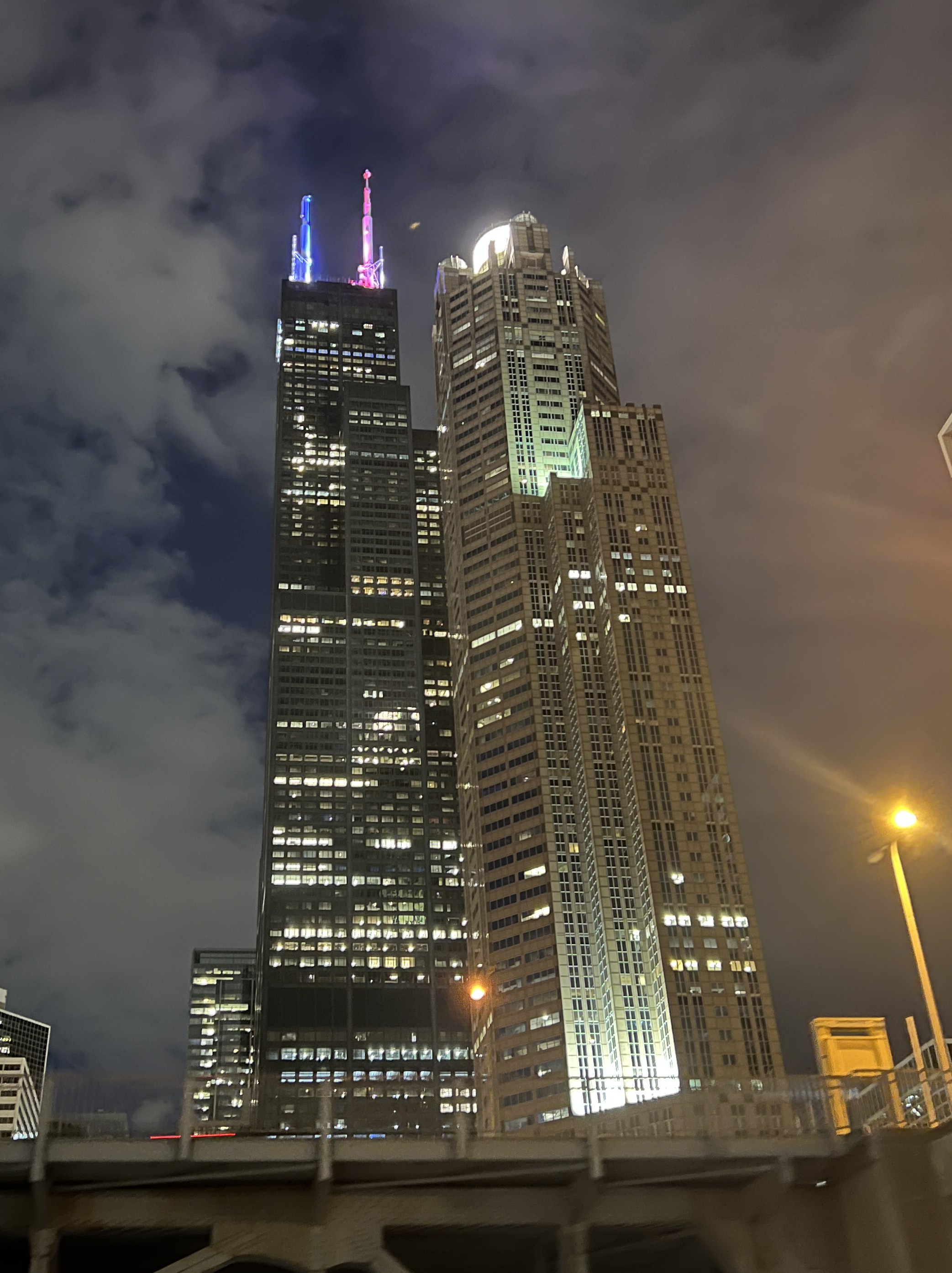
Willis Tower stands at a total height of 1,451 feet (approximately 442.3 meters) and comprises 108 floors above ground and 3 floors below ground. When it was completed in 1973, it was the tallest building in the world and held this record for an impressive 25 years until it was surpassed by the Petronas Twin Towers in Kuala Lumpur in 1998.
History
In the mid-20th century, at the height of Sears, Roebuck & Co.’s dominance in the U.S. retail industry, the company’s rapidly growing business and expanding scale made it clear to Sears executives that the existing headquarters, located in what was then the western suburbs of Chicago, could no longer meet the company’s needs. In 1966, the Sears board of directors decided to begin planning a new headquarters building. They commissioned the renowned architectural firm Skidmore, Owings & Merrill (SOM) to design the new tower.
Based on company projections, the board planned for the new building to provide at least 390,000 square meters of office space, with any remaining space to be leased to other tenants. Initially, the board proposed that each floor cover 100,000 square feet (approximately 9,300 square meters), and the total number of floors would be determined according to company needs. However, SOM’s architects argued that excessively large floor plates would make it difficult to lease the surplus space. To ensure the building’s rental viability, SOM proposed a design in which lower floors would each cover 55,000 square feet (approximately 5,100 square meters), with floor areas gradually decreasing on the higher floors.
After discussion, the board ultimately accepted this plan. At the same time, however, the board’s overly optimistic projections for Sears’ growth led them to realize that, under this design, the new headquarters would be unexpectedly tall. On July 27, 1970, SOM announced a staggering design for a skyscraper approximately 1,450 feet tall (about 442 meters) with roughly 110 floors, which, once completed, would become the tallest building in the world (measured from ground to roof). Construction of the Sears Tower officially began in August 1970.
Bundled tube structure
One of the most critical considerations for any skyscraper is how to support its immense weight while maintaining stability under lateral loads, including extreme weather and seismic forces. Traditional solutions include installing tuned mass dampers on upper floors (as seen in 150 North Riverside Plaza) and incorporating hollowed-out designs on upper levels (such as The Residences at The St. Regis Chicago). However, both approaches have drawbacks: the former occupies a significant amount of interior space, affecting economic efficiency, while the latter can compromise the building’s aesthetic appeal.
To achieve the best of both worlds, SOM’s architects innovatively proposed the tube structure and bundled tube structure designs. In a tube structure, a series of closely spaced load-bearing tubes are constructed along the perimeter of the building to serve as the primary structural framework responsible for stability. These main tubes are interconnected through carefully designed structural links that provide mutual support. Inside the building, additional auxiliary tubes are installed; these are connected to the main tubes via beams and help evenly transfer the building’s weight to the perimeter tubes.
Buildings employing a bundled tube structure are composed of multiple tube-structured units combined together, each with slightly different dimensions. Typically, one or two of these units reach the building’s maximum height, representing its tallest sections. Surrounding these taller units are shorter units, which not only form part of the overall structure but also help stabilize the taller units, enhancing the building’s overall structural integrity. Architects determine the specific number and arrangement of these units based on local weather conditions, soil, and other factors. The Willis Tower, for example, utilizes a bundled tube design composed of nine such units.

Tube structure and bundled tube structure have become standard structural systems for skyscrapers since their introduction in 1970, and have been adopted by many subsequent high-rise buildings. More examples can be found at https://en.wikipedia.org/wiki/Tube_(structure)#Concrete.
Skydeck
Skydeck is an observation deck located inside the Willis Tower, on the 103rd floor. It is the highest indoor observation deck in the United States. From here, you can enjoy panoramic views of Chicago’s cityscape in all directions.
Did you know?
• It is rumored that during the early design discussions of the Sears Tower, the architects at SOM used 9 cigars to simulate the 9 units of the building to test its structural stability.
• The method of calculating building height has historically been a subject of controversy. When the Petronas Towers in Kuala Lumpur were completed in 1998, their developers claimed they had surpassed the Sears Tower to become the tallest buildings in the world. This claim was met with opposition and strong dissatisfaction from the developers of the Sears Tower and the people of Chicago. At that time, to clarify the calculation method and resolve the dispute, four different methods of height calculation were proposed. Among these four methods, the Petronas Towers were only the tallest when measuring from the ground to the highest architectural element.
• The headquarters of United Airlines, one of the major airlines in the United States, is located in the Willis Tower. At the same time, United Airlines is also the largest tenant of the Willis Tower, occupying 20 floors of the building.
St. Regis Chicago
The St. Regis Chicago is located on the east side of the Chicago River near Lake Michigan. Built in 2020, it stands 1,198 feet (approximately 365 meters) tall with 93 floors, making it the third tallest building in Chicago, after the Willis Tower and the Trump International Hotel and Tower. It is also the tallest building constructed in Chicago in the 21st century. As the name suggests, the primary function of the St. Regis Chicago is hotel accommodation, and it is mainly operated by the St. Regis Group. The first ten floors of the St. Regis Chicago contain 192 hotel rooms, while the remaining floors are residential, with a total of 393 extraordinary lake-view residences. Guess how much a lake-view residence costs?
The St. Regis Chicago consists of three buildings of increasing height, with a distinctive sea-blue wavy exterior that evokes the undulating ocean. To ensure the stability of the building, it employs a buttressed core structure internally. The buttressed core structure consists of a central main load-bearing column with several wings attached to it and connected to the ground. This structure is different from the bundled tube structure, but it is equally effective in distributing the weight of the building. The buttressed core structure inside the St. Regis Chicago has three “Y”-shaped wings with equal angles. To resist wind loads, the 83rd floor of the main tower of the St. Regis Chicago is designed as a hollow space, with no decoration, windows, or elevator stops, allowing wind to pass through and reduce wind pressure. This design decision was made by the design team after conducting wind tunnel tests during the design process.
Did you know?
• The lead architect of the St. Regis Chicago is the renowned female architect Jeanne Gang. At the time of its completion, it was the tallest building in the world designed primarily by a female architect.
• The Chinese Wanda Group was one of the main companies responsible for developing the St. Regis Chicago. When the hotel was completed, its official name was Wanda Vista Tower. Due to various external factors, Wanda Group sold all its shares in April 2019, after which the hotel was renamed to its current name in 2020.